Trail marker trees #3

MARQUETTE – Our April trail marker tree articles asked for help in locating more of these living artifacts. Fourteen readers contacted the Marquette Regional History Center. Over the next two weeks I looked at crooked trees from Gwinn to Big Bay and on back roads and hiking trails in between.
Two of the trees reported, have long been known as local landmarks, but not necessarily recognized to be the trail markers they were. Two others were found to be trail markers not previously reported or documented. Several other trees had some characteristics of authentic trail markers, but were not old enough to have been shaped by Native Americans who relied on bent trees to help them navigate through the wilderness.
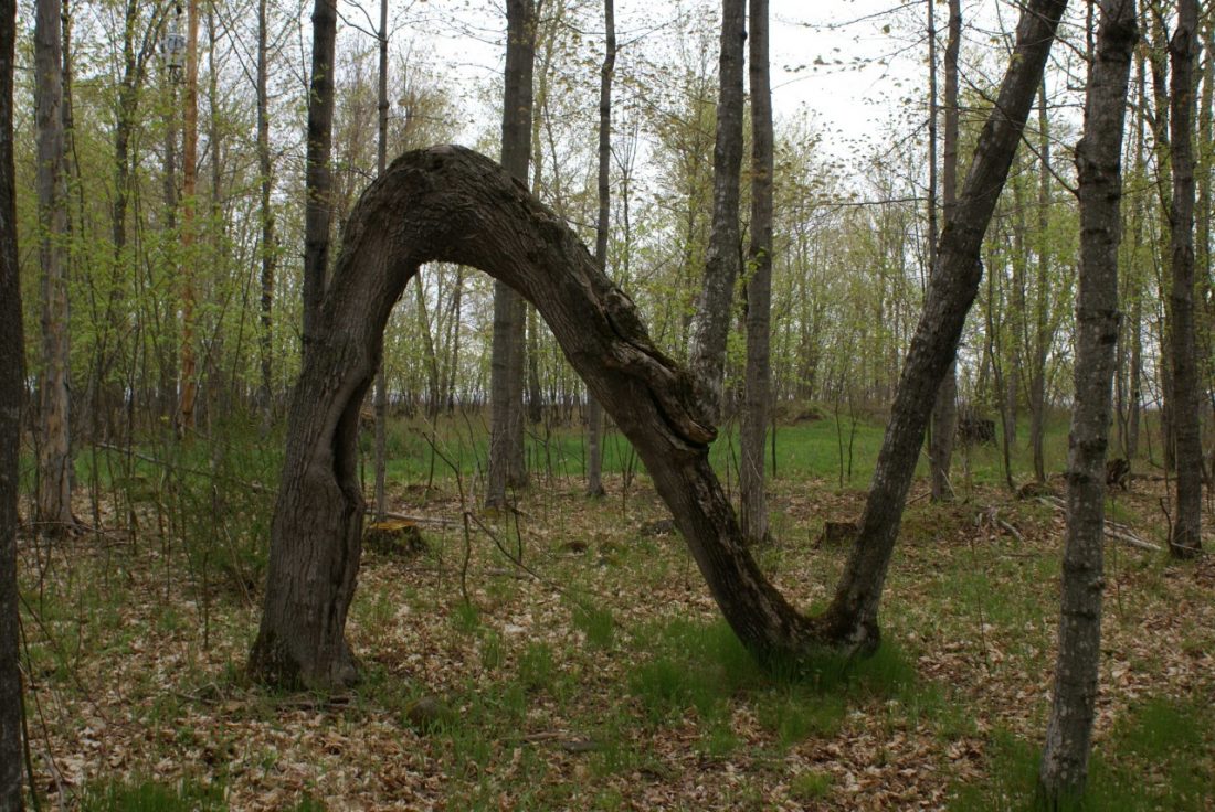
Some readers will look at this photograph and say, “Oh, I know that tree!” Coming across it during a hike at Marquette’s Presque Isle Park, seems to trigger an impulse to sit down and have one’s picture taken. I’ve heard two nicknames for this 25-inch diameter monster: “The Dinosaur Tree” and “The Presque Isle Dragon.” It is obviously very old, and has the classic trail marker shape. Three readers called to report this under-appreciated local treasure: John Argeropoulos, Scott Cripe and Ann Haseltine.
The Dinosaur is lower to the ground than most trail markers. We suspect that it may have originally been higher, but sunk down as its weight increased. Any reader who has a photograph of this tree taken during the 1920s or earlier, is encouraged to contact the Marquette Regional History Center, so that a copy of it can be made and added to the historical record.
Since this old sugar maple is on public property, we are free to give directions to its location. Drive (or walk) on the road that loops around Presque Isle Park, until you reach a small parking area on the right side, just before the road starts curving down toward the Black Rocks. Two trails lead downhill from the parking area, in an easterly direction. Take the right-hand one. The Presque Isle Dragon is about a two-minute walk from there.
Another Marquette County tree that deserves more recognition than it has received, is this spectacular specimen, referred to as “The N-Tree,” by those who are familiar with it. Marquette resident Fred Huffman called this trail marker variant to our attention. After his family purchased a camp on the north shore of Lake Independence in 1959, young Huffman and his pals liked to explore the woods and beaches on and around Lighthouse Point.
Of the N-tree, Huffman said, “I do recall seeing and playing on that tree as a young kid, but had no idea what it represented.”
Many years later, Huffman’s friend, the late teacher and storyteller Fred Rydholm, told him that there was a good possibility it might be an Indian trail marker.
We know of no other tree in Marquette County shaped like this one, but trees of the same configuration have been found in widely scattered areas of the United States. The tree we call “N” is not simply a trail marker. Its special shape conveyed a message that we, 200 years later, do not understand. Research into the early history of Lake Independence and Lighthouse Point, and knowledge of Native American traditions might solve what is now a cross-cultural mystery, and tell us more about this very remarkable, and fragile, old sugar maple.
Next week’s article will show and discuss two more trail marker trees, neither of which have been previously documented. One is in Chocolay Township, and the other is near the shore of Lake Superior north of Marquette.


